Thursday, February 5, 2009

Istria

A 2001 NASA satellite map of the Istrian Peninsula. The Gulf of Trieste and the Alps are shown in the left of the satellite capture. The Croatian islands in the Gulf of Kvarner are to the right.


The largest peninsula in the Adriatic Sea, Istria comprises land areas of three countries: Italy, Slovenia and Croatia. Situated in the northeastern Adriatic opposite Venice, Istria's northern border is the Gulf of Trieste (Italy); the eastern limit is the Gulf of Kvarner, with its deep water port city of Rijeka (Croatia).

Croatia (Hrvatska in the native Croatian language -- important to know) occupies 89% of Istria's land mass, and most of the remaining portion lies within Slovenia. Italian Istria is just two tiny municipalities, Muggia and San Dorligo della Valle, both of which lie just south of Trieste. Click on map to enlarge.


In modern times, Istria was part of Italy until 1945. For some 500 years it was the summer playground of the Venetian Republic. The city of Venice, just a two hour boat ride away , is visible across the Adriatic on a clear day. Istria retains a distinct Italian flavor. Architectural reminders, such as piazzas and Tuscany-style stone farmhouses, are everywhere. Most towns have at least one church with a campanile (bell tower). Italian aromas fill the air from restaurants serving gnocchi, truffles and classic northern Italian fare.

Note for tourists: In Italy and Slovenia, the Euro is the unit of currency. In Croatia it is the Kuna, although Euros are widely accepted throughout Istria. One US dollar buys 7 Kuna.


The name Istria comes from the Histri tribe of the Illyrians. It took the Romans two military campaigns to subdue them (in 177 BCE). After the fall of the Roman Empire, Istria was occupied by Goths, Lombards, Franks (Pippin III in 789), and the dukes of Merano, Bavaria and Carinthia, before becoming part of the Venetian Republic in 1267. The area near the border between Slovenia and Croatia was especially valuable to Venice, because of its salt pans, which remain productive today. Inland portions of Istria were under the control of the Holy Roman Empire, and later the Hapsburgs and Napoleon.

Note to travelers:
I would suggest using the Trieste, Italy airport (TRS airport code) northwest of the city at Monfalcone just off this map at the tip of the top left arrow. There are twice daily Lufthansa nonstop one-hour flights from Munich (MUC airport code). Trieste (black area at top of map) abuts Slovenia (orange area of map). Green area is Croatia. Visit in order Piran, Groznjan, Motovun, Hum, Porec, Pula, Rovinj. The best (Piran and Rovinj) are thus first and last.


Tuesday, February 3, 2009

Piran (Pirano)

Piran is a small walled town (population +-5,000) in Slovenia occupying a promontory on the Adriatic coast southwest of Trieste, Italy. Situated at the tip of a scenic peninsula, the town looks thoroughly Italian, with medieval, Renaissance and neoclassical architecture. The photograph shown in this blog's title box is of Piran. Narrow streets and centuries-old buildings give the town its special charm. Most of Piran is a pedestrian area; in 2008 the main square was remodeled to eliminate automobile traffic and parking.


Piran is one of Slovenia's major tourist attractions, and along with the towns of Koper, Izola and Porotorož, forms the principal coast area of Slovene Istria. The municipality is bilingual, and both Slovene and Italian are official languages; the Italian name for Piran is Pirano.

Piran is the birthplace of noted Baroque composer and violinist Giuseppi Tartini (b. 1692). In 1892 the city erected a large-than-life statue of Tartini, which is placed on a pedestal at one end of a large polished marble oval that forms the main area of the town square, Tartinjef Trg (Italian: Piazza Tartini). Prior to that time this area was a protected inner harbor, but sediment and stagnation led to its being filled in.

High above Tartinjef Trg is Saint George's Cathedral, from which expansive views can be enjoyed. A separate octagonal baptistry and clock-faced campanile share the cathedral grounds (see photo below).

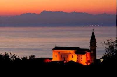
Standing at the tip of Piran's peninsula, in the vicinity of the church of St. Clement, it is possible to see the Italian Alps, the Gulf of Trieste and the Croatian coast, all in one sweep. The photo below shows the Italian Alps across the Gulf of Trieste, as viewed from atop the old city walls. The church in the foreground is St. George's Cathedral.


PIRAN PHOTO GALLERY

Tartini's statue can be seen in the lower right of this photo:
The view of Piran's harbor as seen on the walk into town from the municipal parking lot (a free shuttle bus is also available).


The ancient crenelated walls protected the town from an attack by land. The coast of Croatia is seen in the distance in the first photograph below.

The cobbled pedestrian-only streets and arched passageways are stage-set picturesque. Venetian Renaissance architecture on Tartinjef Trg:

Piran's streets were built intentionally narrow for protection from the wind and rain, since the town is built along a slender peninsula.

Sunday, February 1, 2009

Pula Roman Arena


The Pula arena is an ancient stone amphitheatre located in Pula, a port city on the southwest coast of the Istrian Peninsula of Croatia. This arena is the only remaining Roman amphitheater to have four side towers and all three Roman architectural orders entirely preserved. It is the sixth largest surviving Roman arena, having replaced a smaller stone ampitheatre in 79 AD; the enlargement to a capacity of 23,000 spectators was necessary in order to accommodate crowds drawn to the gladiator fights. This arena remained a part of the gladiator circuit until the 5th century, when Roman emperor Honorius prohibited gladiator combats. However, it was not until 681 that battles between convicts (with a death sentence) and wild animals was forbidden (and to think we get upset about dog fighting these days).

Each of the four towers had two cisterns filled with water that fed a fountain and powered primitive misters that sprinkled perfumed water onto the spectators. This amphitheatre could be covered with large sail cloths to protect the spectators from sun or rain, as attested by intact rare construction elements. A series of underground passageways was built underneath the arena along the main axis, from which animals, scenery, performers and fighters could be released; stores and shops were located under the rows of raked seating. The present day museum under the arena has exhibits of Roman wine making and olive oil processing; both of these Istrian products were goods highly valued by the Romans.

In the Middle Ages the interior of the arena was used for grazing, tournaments by the Knights of Malta and fairs. In 1583 the Venetian Senate proposed dismantling the Arena and rebuilding it in Venice, but this plan did not come to fruition. In 1709 some stones from the arena were used for the foundations of the belfry of Pula’s cathedral. In 1932 it was adapted for theater productions, military ceremonies and public meetings. In its present state it seats some 5,000 spectators.

Il Divo: Amazing Grace
Recorded and videotaped at the Arena in Pula, September, 2008, complete with bagpipers and full symphony orchestra. "Amazing Grace" is from the Il Divo CD "The Promise" and DVD "Il Divo at the Coliseum."
Extreme trivia: bagpipes play only in the key of E-flat, so we don't have to guess which key they sing in after the bagpipes enter.

http://www.youtube.com/watch?v=mMVxzEueJ6A&NR=1

Il Divo (Italian for “star” or “celebrity”) is a multinational operatic/pop vocal group created by Simon Cowell (yep, the one from “American Idol”). Cowell conducted a worldwide search for young male singers who were willing to embark on his 2001 “Il Divo” project in an effort to create a “Three Tenors” ensemble with repertoire leaning more toward pop music. And, like the Three tenors, they tend to bellow full throttle. In December, 2003, a fourth member, American tenor David Miller, was signed. Il Divo comprises a renowned Spanish opera baritone, Carlos Marín; two classically trained tenors, Swiss Urs Bühler and American David Miller (he starts the second verse in the video above); and a French pop singer, Sébastien Izambard (the only group member who was not classically trained; hint: he's the one singing solo at the start of the video posted above). Definitely not to everyone’s taste, but Il Divo has become an international sensation, and (in an age rife with spin-offs) to date they have no serious competition. Plus, they have caused a spike in sales of Armani suits. Way more than you wanted to know.

October 18, 2003: Cravat around the Arena

Staged as a major work of world performance art, which was seen on television throughout the world by an estimated one billion viewers, “Cravat around the Arena” was considered the most ambitious promotion of the Croatian identity in the world to date. The necktie originated in Croatia in the seventeenth century. This installation, incorporating the largest cravat in the world, symbolically brought together the ancient and modern ages, and the red color of the cravat sent a message to the world of love and life together of peoples and nations. Most of the grunt work of the installation was accomplished by Pula high school students.

Trivia: the knot was not tied beforehand, and its execution presented major complications and trials for the installers; between the knot and the harbor, the tie was strung up over a street (which remained open to traffic) and extended over to a large parking lot.

Few people are aware that neckties originated in Croatia around 1635. The word “cravat” is derived from the word “Croat,” and neckties are descended from the neckwear that Croatian mercenary soldiers wore. Because some Croatian mercenaries were stationed in large, fashionable cities such as Paris and Prague, this “Croatian style” greatly impressed their foreign counterparts. Croatian military officers wore tied neck scarves made of silk, and French men adopted this new fashion during the reign of Louis XIV, referring to it as “a la Croate.” Eventually, it became known by the French word “cravate.” The tie entered the bourgeois fashion of that era as a sign of cultivation and elegance and went on to conquer the whole of Europe. In contrast to the lace collar that had to be kept white and carefully starched, the cravat was simply and loosely tied around the neck without need for any additional care. Today, men across the entire civilized world wear neckties. Unlike many fashions, which fade or disappear over time, the necktie has retained its popularity for hundreds of years and is still considered a basic item of most men’s wardrobes, rather than just a decorative accessory.

Saturday, January 31, 2009

Rovinj (Croatia)


Rovinj (Croatian)

Ruvèigno (Istriot)

Rovigno (Italian)


One of the most beautiful towns on the Istrian coast, Rovinj (Croatia), a city of 15,000 inhabitants, is an active fishing port and tourist resort.

Rovinj is one of a handful of towns in which the rare Istriot language is still spoken (it is estimated that only +-1,000 speakers remain). Originally the peninsula on which the old town lies was an island, separated from the mainland by a channel, which was filled in 1763. The Rovinj Archipelago includes 22 islands, one of which (Santa Katarina) extends into the harbor. Rovinj enjoys a Mediterranean climate with subtropical vegetation.

Rovinj attracts a sizable number of foreign tourists, especially Austrians and Germans, although the recent proliferation of low-cost flights to the area from London has resulted in a noticeable increase in tourists from the UK. During the summer a high speed ferry service connects Rovinj with Venice.


From 1283 to 1797 Rovinj was one of the most important towns of Istria under the Venetian Republic. The city was fortified by two rows of walls with three town gates. Close to the pier one can find an old town gate (Balbi's Arch) dating from 1680, and a late-Renaissance clock tower. The old town is dominated by the church of St. Euphemia and its Italianate tower (campanile).


After the fall of Venice and the Napoleonic period, Rovinj was part of the Austrian Empire until World War I. The city then belonged to Italy from 1918 to 1947, when it was ceded to Yugoslavia; during this period, most of the Italian inhabitants fled. Today three quarters of the citizens are Croats, and only 16% are Italian.

The 4-star Villa Angelo d'Oro Hotel reflects the traditions of its Austrian owners:


Restaurant Monte (below) inside and out.


The streets of the old town are cobbled with smooth, white stones:

Katarina Island seen from the tower of St. Euphemia church:

A picturesque courtyard in the old town:

Friday, January 30, 2009

Bora (winter wind)

The cold bora wind affects the entire Istrian Peninsula. It is a katabatic wind, like the Santa Ana in California and the Mistral in the Mediterranean. Katabatic winds are downdrafts that carry winds from higher to lower elevations. In this instance, the heavier (colder, denser) air over the Alps is carried by gravity down to the warmer, lighter air over the Adriatic.

Above: the mean streets of downtown Trieste, Italy, during the occasion of a bora wind.

The bora, which occurs most ofter in winter, affects Croatia, Slovenia and Italy. It blows in gusts. On March 15, 2006, a gust was clocked at a bridge in Croatia at more than 155 MPH (235 KPH). The bora can last for several days at a time and usually occurs several times each year (on average about 40 days a year). Coastal towns are built densely with narrow streets, in part because of the wind. Buildings in several towns and villages in Slovenia and the Italian province of Trieste have stones on their roofs to prevent the roof tiles from being blown off. It is not uncommon to see entire rows of motorcycles and mopeds blown over onto their sides in Trieste.

Chains and ropes are occasionally stretched along the sidewalks in downtown Trieste to facilitate pedestrian traffic; there is a danger of being blown off one's feet and into traffic! (click to enlarge photo)


Italian: bora
Slovene: burja
Croatian: bura

Trivia: The Volkwagen models Bora, Sirocco and Passat are all named after winds, with the insinuation that their cars "move like the wind."

Tuesday, January 27, 2009

Muggia & San Dorligo della Valle


Muggia is a municipality (“comune” in Italian) immediately south of Trieste, Italy. It has a 7-mile-long coastline along the northeastern Adriatic, forming the northern extremity of the Istrian Peninsula. Muggia shares a border with Slovenia to the south. The western limit of the comune is home to San Rocco, a spa port that today houses a pleasure craft harbor and luxury hotel.

Although Muggia can trace its origin back to the 7th century BCE, the most important date in its history is 1420, when Muggia was incorporated into the Republic of Venice. Much evidence of its association with the Serene Republic can still be seen today, chiefly in its dialect, cuisine and architecture. The main square around the town hall and Cathedral of Saints John and Paul (c. 1263) is a true “campiello” (see photo above). The church has an unusual scalloped white stone facade that incorporates a tracery rose window with Mary and the infant Jesus sculpted in its center.

After the fall of the Venetian Republic in 1797, Muggia became part of the Austrian Empire, developing an important naval construction industry that flourished until after World War II. The neighboring city of Trieste was the principal port of the Hapsburgs.

Muggia has a crenelated 14th century castle that was restored by its current owner, sculptor Villi Bossi (see photo below). There is a celebrated annual Carnival (carnevale muggesano) that engages most of the town’s citizens, who act out religious allegories while dressed in elaborate costumes.


San Dorligo della Valle is a comune that lies due east of Muggia. It also shares a border with Slovenia. Unlike Muggia, which is populated almost entirely by ethnic Italians, 70% of the inhabitants of San Dorligo della Valle are ethnic Slovenes.

Photo: The hilly Karst region of San Dorligo della Valle.

Monday, January 26, 2009

Poreč (Parenzo)


Set along the western coast of the Istrian Peninsula, Poreč (Italian: Parenzo) is almost 2,000 years old, and is centered around a harbor protected from the Adriatic Sea by the small offshore island of Sveti Nikola (St. Nicholas). The town's population of approximately 12,000 resides mostly outside the historical center.

The old town's streets are paved with smooth white stones.


In 1267 Poreč became the first Istrian city that chose to become part of the Venetian Republic, and Venetian architecture can still be seen all around the ancient streets of the old town sector.


But the most important historical structure is the sixth-century early Byzantine Basilica, a UNESCO World Heritage site since 1997. Built in 553, the Euphrasian Basilica is named after Bishop Euphrasius of Poreč, who in the 6th century commissioned the building of this grandiose three-nave basilica on the site of an earlier church. The Euphrasiana complex is comprised of a church, baptistry, atrium and the former Bishop’s Palace. Of particular interest are the mosaics in the apse, as well as marble slabs with mother-of-pearl and multicolored stone incrustations.


The first sacred structure on the Basilica’s site was Maurus’ Oratory, built in the second half of the 3rd century (portions of the mosaics have been preserved) as one of the first places for corporate worship by Christians. Maurus was the first Bishop of Poreč, and is today the patron saint of Poreč and its diocese. In the period of the bloodiest persecution of Christians during the rule of Emperor Diocletian, he was executed together with the entire clergy of Poreč. His relics are housed today in Euphrasius’ Basilica.

For more than 40 years during the summer months, the basilica in Poreč has been a venue for classical music concerts. Renowned musicians from Croatia and abroad perform there. The atrium of Euphrasiana (see photo below) is the setting for chamber music concerts, notably those incorporating the harpsichord.

Poreč: Sunset over the Adriatic